VENUE: Semenyih Fish Valley
Taman Sri
Haneco, Jalan Sg Lalang, 43500 Semenyih, Selangor
(GPS Coordinates: N2 58.186 E101 52.128)
(GPS Coordinates: N2 58.186 E101 52.128)
DATE: Sunday 8th December 2013

Pre-Event
I heard of this event through
Edward. When he said that this event was a good event to join as he had heard
of it through his other cycling buddy, I too signed up trusting Edward’s judgement.
Little did I know what was installed for me.
Edward persuaded Ernie and their other
cycling enthusiast buddies, “Funkier“
group to take part in this event also. This would be their maiden participation
in any cycling event. The “band of
brothers” trained very diligently every weekend, cycling in FRIM, Kesas Highway, Kemensah and Jalan Gombak/Genting
Sempah. I joined in the training
whenever I could find the time.
Event Day
We met up at 6:00 am and drove to the car park
across the road to the Fish Farm. We
were early and there was plenty of time for us to assemble our bikes. We took a
group pic at the car park and cycled to the assembly/starting point. A briefing was given by the organiser and we
set off at about 8:00 am.
 |
| Pic 1: Funkier Group at the car park all ready for the adventure |
As usual for a bigger view of the pictures, place mouse pointer onto the pic and left click the mouse button.
Loop 1 (11 km)
Loop 1 (11 km)
 |
| Pic 2 : traffic jam in the jungle |
Loop 1 was mainly slow going, right at the first
insertion point into the jungle trail from the tar road. Even though the insertion point was wide
enough for two or three riders, the sheer number of cyclists just jammed up the
insertion point. I remembered that it
was mainly a single file, slow march of riders on foot. Met a friend, Lawrence from another company
whom we had dealings with and while waiting for the line to moved we talked
about work related stuff.
Going downhill was fun. Towards the end of Loop 1, the single file
bottleneck restarted as everyone was reaching the stream near CP1. We had to cross a small stream and hence got
our feet and bikes wet.
 |
| Pic 3 : hill top view of surrounding |
 |
| Pic 4 : Hill view in color |
When I checked the time, it was
about 9:30 am. I had finished one bottle
of water. I told myself, “Okay. I made good time. From memory, Loop 2 cut off
time as 10:30am and Loop 3 cut off time should be 12:30pm. I should complete Loop 2 at about 11:30am. I would
have an hour to spare”
Foot note: I was wrong the cut off
time for Loop 2 was 12:00 pm
Loop 2 (12 km)
At CP1, I took the opportunity to refill my bottle
of water. I had only brought two 750ml water
bottles of water, one muesli bar, one power gel and two power bars (one of
which was from the goody bag). It was a
quick short stretch on the road and into the oil palm estate again. The crowd
had started too dissipate. We were now
in smaller groups. Again more climbs.
The first loop had set the slow pace for me.
I started to push my bike up the climbs and rode the bike on downhills.
It had rained for most days of the week including
Saturday. On event day the weather was generally kind to us and during Loop 2,
it was mostly overcast and cloudy.
I saw a rider with a broken pedal. He was pushing his bike while holding on to
his broken pedal. Now that was
determination. He still trudged
along. I thought to myself that was the
end of the ride for him. I saw him twice
along this loop as he must have overtaken me on the downhill stretches while I
caught up to him on the uphill stretches.
I cannot remember much of Loop 2 but whatever I
remembered would have been wiped out by what I was to encounter in this
loop.
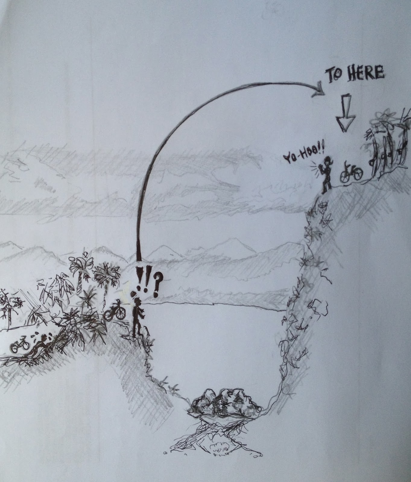
As we were climbing out of the jungle, we came to a
drop in the terrain which led to a river valley. The cycling trail just seemed to end at that
point. Right in front of us was a sheer slope
climbing up from the river valley. The continuation of the biking trail was at
the top of that steep slope.
It was a sight to behold. That sight, as I came up to the "ravine" gave
me a feeling of awe and disbelieve. I
was transformed into a War Movie scene. The
whole scene at the "ravine" just reminded me of a war scenario where, we the
platoon of “soldiers” had ran into the jungle to escape. But our escape route was cut short by a deep
ravine. We had no choice but to climb
down and up the steep "ravine" to escape the approaching enemy. They say a picture is worth a thousand words,
so the picture below best described the moment.
 |
| Pic 5 : OMG !! |
From the bottom of the "ravine", I saw three columns of
riders (one to my left, one in the middle and the last to my right) trying to
climb the steep slope. Each column of
riders were climbing the slope across the ravine with their bikes in tow. A Marshall was there and I asked him which route
was the easiest to ascend. The Marshall
advised me to go for the option to my left.
Other riders must have decided not to wait in line up the slope via the
easiest route (to my left) and had decided to try to cut the waiting time by
ascending the slope via another route. I
stood there cursing to myself, “This is not a MTB ride! This has turned out to
be a “cross-country lug your bike up the steep slope” ride.
After assessing the options, I went for the
right most option as it had the shortest queue. I carried my bike down the slope to the river
bed. We still had to wait in line.
After waiting for a few good minutes there was still no progress. I decided to turn back and joined the queue
using the easiest option i.e. to my left.
 | |
| Pic 6 "Soldiers” climbing down the slope to the bottom of the river | "ravine" on one side |
The good thing about this particular challenge was that you could see the riders helping each other ascend the slope. One column of riders had formed a chain and helped to carry their bikes up the slope first before climbing up slope.
Next to me were a few female riders and they were
to have a difficult time climbing up the slope with their bikes.
Pic 7 below shows the steep slope on the other side of
the "ravine" where we had to climb up
 |
| Pic 7: Steep slope on the other side of the ravine |
 |
| Pic 8:This shows a zoomed in view of the Pic 7 (near the top) showing the “soldiers” with their bikes in tow. |
The two pics (Pic 7 and Pic 8) would give one a reasonably good idea of the scale and size of that #%#@ slope where we had to lug our bikes up. Pity the guys with full-sus bikes and the ladies.
Just before CP2 where I was cruising downhill, I witnessed an accident. I saw a cyclist lying down and bleeding from the knee being attended to by another cyclist. A Medic had to bring a stretcher with him from CP2 to the accident site. An ambulance was on stand-by at CP2 but the injured person had to be carried out. Luckily the accident happened not far from CP2. I was thinking to myself that it would be good to have an ATV to drive in but alas the trail was too narrow for an ATV. We were all walking in single file to CP2. There was the usual jam as it was a single track trial.
I had finished 1.5 bottles of my water. I took the opportunity to refill my two water
bottles and gobbled two bananas. True enough,
coming up to CP2, I overheard one female rider’s conversation with the
Marshall. She was throwing in the towel. She said that she could not go on and opted
for the chicken route. The killer
“hike-a-bike” slope did its toll.
I noted the time on my watch, it was 5 minutes to
12:00pm. The Marshall said that he was
closing Loop 3 in 5 minutes. I then
realised that I was mistaken in thinking that the cut off was at 12:30pm. I was surprised at how long it took me to
complete Loop 2. The steep hill climb and the ravine were to blame.
Loop 3 (17km)
The sun had finally come out to play and it was
getting hotter. I began to slow down
and was feeling hungry and tired. I took
out the power gel. I had asked Edward to help me buy caffeine
free power gel. It was my first time
trying power gel, it just tasted very, very sweet. I continued my pushing the bike up the steep
slopes and thankfully cruising down the descents. This seemed to continue on and on….
Another “pleasant” obstacle that the organisers put
up, again reminded me of a “war zone. We
were cycling in secondary jungle but out of the blue there was a clearing we
had to cycle through. This time the
whole ground was littered with fallen tree logs.
 |
| Pic 9: Another war zone |
We again had to carry our bikes over the closely spaced fallen logs. I wondered if any gung-ho cyclist tried cycling over the
ground of logs? Perhaps the guys on 29inch MTBs?
As the organisers mentioned in their notes, Loop 3
was a mix of everything. It went through
oil palm estates, rubber estates and secondary jungles with good jungle canopy
cover. There were uphill climbs and
descents also. Heck, there was even a
river crossing to wash and cool down. I
think I cycled through about 3 river bridges, ranging from small crossings made
up of a few logs tied together to a huge metal plated/concrete bridge.
I was getting tired, hungry and weary. I finished my two power bars and was soon
running low on water. The two 750ml
water bottles were not enough. On one
stretch, in the rubber plantation two riders suffered cramps at approximately the
same spot. I had stopped and was resting
near that spot. The whole area was a
nice shady spot to rest. One rider had
the cramps and fell to the ground, the other just stopped and could not
move. He remained stationary unable to
get off his bike. One of the other riders
had to stabilise his bike and slowly helped him get off his bike to sit on the
ground.
 |
| Pic 10 : cooling down by the river |
It was getting hot and a welcome relief to some of
riders was when we came across a stream. The stream was wider and deeper than the first
one in Loop 1. I was advised by the old
rider whom I met (see Riders Section at the end) to carry my bike and not wet
the gears. I stopped, secured my phone
and wallet in the water proof bag and waded across the stream carrying my heavy
bike.
Some of the bikers were really enjoying the cool
water and were casually floating about in the water. I too was tempted to just stop and enjoy but
decided against it.
We cycled on and came across another scenic rubber plantation and lake.
I had to stop to take a pic.
 |
| Pic 11: scenic rubber plantation with lake in the background |
 |
| Pic 12 : black & white rendering of pic 11 |
So on we went the last group. Pushed the bikes up
the last hill (so we thought). We went
up that hill and cycled for a while before we came to another hill to
climb. Oh No!! Couldn’t believe it! We fell for the old “last hill left to climb” routine. It was at this point that I was thinking it
was a better idea to take the easy flat road back to the Fish Farm.
Anyway we trudged along and from my conversation
with the young rider next to me this PCC ride was his first ever ride on his
brand new MTB. He had just bought it two
weeks ago and had only cycled his bike around the house. What a good
introduction to MTB this was for him.
After that second hill, it was all downhill and I whole
heartedly agree with the Marshall. This
section was GREAT MTB cycling country!!!
We passed more jungle and plantations and the most amazing part of this
section was a short length where there were only two rows of perfectly line
trees that we cycled through. The
Marshall described this section as the scene in the Korean TV series, “Winter
Sonata”.
 | |
| Pic 13: What I found that resembled the path I cycled through | . |
My greatest regret was, I did not stop to take
photos. DANG!! I rushed through the section as I was running
out of time and my phone battery had died. I brought a power pack but the connecting wire
was damaged, so in the end – no power to my hand phone and hence no pics. I
totally forgot about my other point & shoot camera in my back-pack.
I had ran out of time and had to get back to the fish farm. I cycled the last 6.5 km on the road back to the Fish Farm as fast as I could. I got my second wind and was pedaling as fast as i could.......
to be continued....
No comments:
Post a Comment