Date: 23 February 2014
The following is a brief description of my first bicycle ride up
Fraser’s Hill.
The Funkier Bikerz Group had planned this trip way
back in December 2013. The plans were
finalised when we were having Chinese New Year “yee sang” dinner in early
February. At the dinner there was a
count of more than 10 who were interested. This number dwindled as D-day loomed nearer.
The plan was to meet in KKB town at 7:30 am, have
breakfast and start our journey at 8:00am. Have lunch up at Fraser’s Hill and
then make our way back to KKB town in the afternoon. Target time back to KL was
5 pm.
Besides the trip being my first bicycle ride up
Fraser’s hill, the journey also gave me a chance to take a trip down memory lane. When I first started working many years ago, I
had to travel to Batang Kali as the developer whom I was working for, had a housing
development there. The site office was
at a shop lot in Batang Kali. Every morning I would drive
from KL to Batang Kali via Jalan Ipoh and Rawang town passing by
Templar’s Park.
This early morning drive to KKB took me on the same
route. Rawang town has prospered and the
roads to Rawang and KKB had improved and were wider. I could still see the row of shops where my
former office was located.
But KKB town still looked the same, quiet and
peaceful albeit this Sunday, I noticed a lot of people. The small public car
park next to the Post Office was bustling with hikers and cyclists.
We started the ride started at about 8:20 am. I had a quick bite of
“kon-low” mee to fill up the tank with carbo. The plate of noodles was nothing
to shout about (perhaps it was because I was gobbling down the noodles in my haste).
The first landmark that we will see is the Sungai Selangor Dam just a few
kilometres from KKB town. One can see a
huge formation of rocks in the horizon as one is cycling along the road. The road leading into the dam's information
centre also has parking spaces for cars.
I noticed a lot of bikers parking their cars there also.
We stopped at the dam for some quick photos at the information
centre. I remembered when the dam was
being proposed, there was an outcry from some parties that were against the
building of the dam. Anyway, be it good or bad for Selangor, the dam was built
and completed in 2002.
Selangor had been experiencing a dry spell. (say what? ..drought in an
equatorial country? ) This was very evident from what we witnessed at Sungai
Selangor Dam.
 |
| Pic of dam and lake when it is full (taken from the web) |
 | |
| Pic of the same spot on the day |
 | |
| Panoramic shot of the dam and water depleted lake |
The pic below was taken at the highest point where we could actually
see the severity of the water
level of the surrounding lake. The waterline of the lake when full can be
easily seen and it is here where we note the severe drop in the water level of
the dam.
 |
| Lookout point overlooking the lake and dam |
(A point to note: On the following Monday, Selangor declared that water rationing was going to be imposed.)
From the look-out point, the road slowly but surely increases in elevation with the occasional
dips in the elevation. As I was cycling
down the road, the remnants of a previous accident still remained. The
heavily log laden lorry must have been speeding down the dip on the road. The
road was curving up the dip and the lorry must have lost control and crashed to
the side of the embankment
 |
| Twisted lorry laden with logs |
The Sugai Chiling Fish Sanctuary
Park is the next landmark that one would encounter along the ride to Fraser’s
hill.
The entrance to the park is just after an old steel bridge. That Sunday both sides of the road were filled
with cars. There were a lot of hikers going into the Park. I too found out later that this was also a
good place to park your car if you intend to cycle up to Frasers. The road from
this point onwards is very well shaded compared to the early stretch from KKB
town to Chiling Park.
 |
| Sungai chiling entrance beside the road leading to Fraser's Hill |
The road that morning was generally empty and the weather was
cloudy. That made for a pleasant cycle up to the Gap. About 8 kilometres before
the Gap there was a popular camping spot with a waterfall just beside the road.
That morning a lot of picnickers were there cooking their meals
 |
| Popular waterfall picnic area just before the Gap |
The picture of the waterfall was taken on the way down. I did not
want to break my cycling rhythm on the way up. It was already late afternoon
and the morning crowd had left. I noted that during that time, there were park
workers cleaning up the early morning mess left by the morning picnickers.
The Gap is
the last resting point before the final 8 km climb up to Fraser’s hill. I was
actually hoping to have a nice English breakfast at the Gap Resthouse. When I
reached the place I was disappointed to find that the place was closed and in
ruins. All the window frames were gone and the entrance was fenced up. What a
disappointing sight to behold
The pic below
was what I remembered the last time I took a trip up to Fraser’s.
 |
| The Gap Resthouse during its hey day right after its refurbishment |
In the olden days before the second road was built for cars to come
down Fraser’s, the Gap road was the only way up and down Fraser’s. The road is only a single lane road. Cars going up and down Fraser’s hill had to
share the road. One hour to go up and the following hour to go down. It was odd hours for vehicles to go up and
even hours for vehicles to come down.
There were caretakers to man the road barriers at the Gap and at the top
of Fraser’s hill so as to ensure that vehicles were going up or down at the correct times.
The Gap Resthouse was a good place to have a snack and a toilet break
while waiting for your turn to drive up Fraser’s Hill. I guess once the additional access road was
built, the Resthouse lost a lot of business as no one was forced to stop and
have a snack while waiting for their turn to drive up to Fraser’s hill.
 |
| At the Gap junction- taking a breather before the final assault |
Instead all I could find was a mini-stall to stop and recuperate before
the final onslaught up the hill.
The pic below shows the current R&R spot. We could still get nasi
lemak, mee goreng and canned drinks from the mini-stall. A not so clean "pay as you use" public toilet is also
available.
After a short refill and picture taking , the two of us stragglers made our
way up.
We had already found out on the mobile that the two road bikes had already reached the top. Oh yes, did I forget to mention that only 5 of us eventually met up at KKB to cycle up Fraser’s hill that day? Two were on road bikes while the remaining 3 used mountain bikes.
We had already found out on the mobile that the two road bikes had already reached the top. Oh yes, did I forget to mention that only 5 of us eventually met up at KKB to cycle up Fraser’s hill that day? Two were on road bikes while the remaining 3 used mountain bikes.
 | ||
| View of the Gap road looking down -at about three kilometres from | fraser's hill |
This gave me more time to stop and take more pictures as I was climbing
that last stretch of the hill.
 | |
| Looks like autumn along the road up from the Gap...but actually its due to a small bush fire scorching the plants and trees |
Finally we made it up. The two road bikers and the one MTB(Ernie) had already eaten and rested. They had time to cool down such that they were starting to feel chilly from the rather breezy afternoon air. Michael and I had our lunch at the open air café just next to the iconic Fraser’s Hill clock tower.
 |
| View of mountainside -about 2 kilometres from Fraser's Hill |
One most certainly MUST take a souvenir shot or two to show off to friends ... hehehe
 |
| Souvenir shot at the Clock Tower |
The
return journey was generally a relaxing downhill ride. The road going
down Fraser's back to the Gap was generally in a poor condition as
compared to the road going up. The road comes out on to the main trunk
road leading to Raub/Bentong. We actually had to cycle pass a concrete
bridge built on the slopes. As we reached the main trunk road, there is
also a "Fraser's Hill" signboard which is more noticeable for travellers
coming from Bentong or Raub heading (i.e from the opposite direction)
to the Gap.
 The
downhill stretch heading back was generally well shaded except for the
last stretch of road passing the dam. There is no shade and one had to
cycle uphill back to KKB. This was a pain as one was already tired and
hot due to the afternoon sun.
The
downhill stretch heading back was generally well shaded except for the
last stretch of road passing the dam. There is no shade and one had to
cycle uphill back to KKB. This was a pain as one was already tired and
hot due to the afternoon sun.All in all the ride up to Fraser's was a good ride. Going up in the morning, one is protected from the sun as the hill offers shade to the cyclist right up to late morning. It would be better to start the climb early and come back down before noon but that that means that you will have to come down immediately and that would defeat the purpose of going up to Fraser's hill. The cool temperatures at Fraser's hill invites you to spend a bit more time up there to chill and relax.
Historical facts of Fraser’s Hill & its surroundings Ref: http://www.fraserhill.info/index.htm
#TRIVIAL FACT No 1 :-
Did you know that Fraser’s hill was originally developed for tin ore mining?
Did you know that Fraser’s hill was originally developed for tin ore mining?
Well I certainly didn’t !!
The following were the statistics of the ride:
Distance :KKB to The Gap = 30 km
Distance: The Gap to Fraser’s Hill =
8 km
Distance : Fraser's Hill to KBB = 41.7 km
Map of ride from KKB to Fraser's hill:
 |
| Note : there was a loss of GPS signal during my ride up : hence the “flat line” from about the 1 hour to the 2 hour duration of my ride. |
As usual double click on the pic for a large view
Map of ride from Fraser's hill to KKB

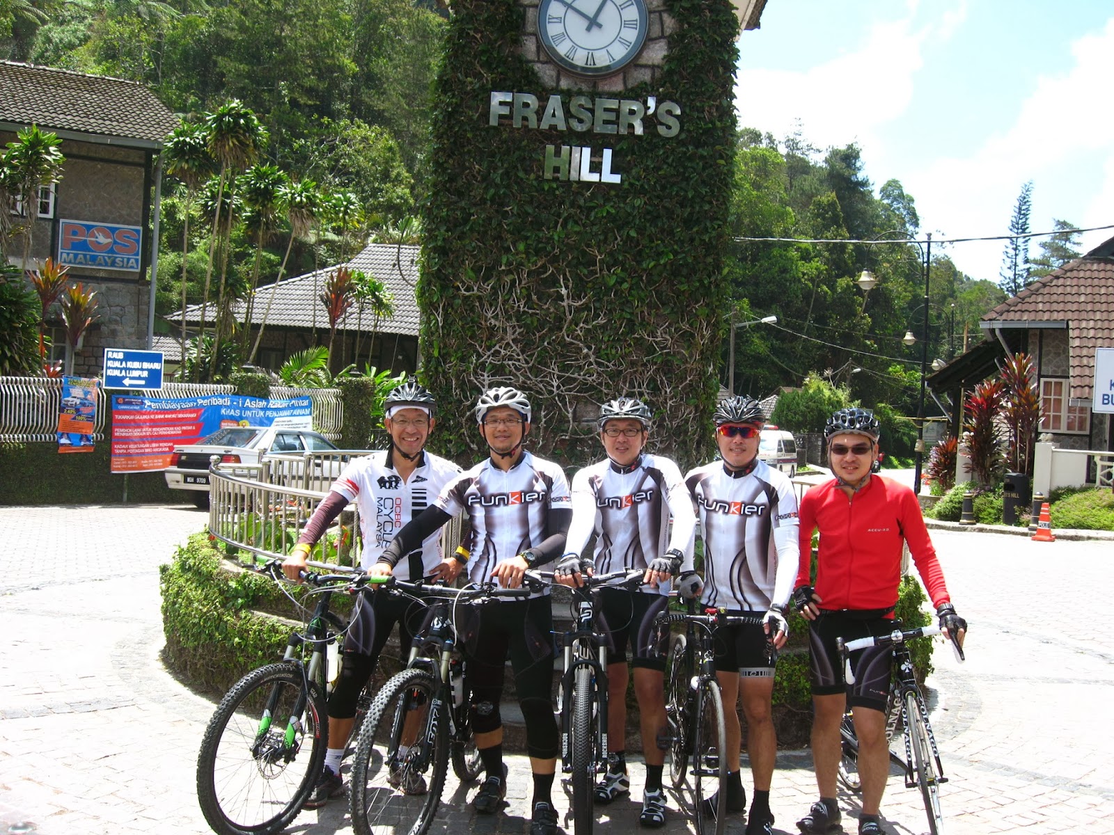 |
| The Funkier Bikers ( left to right: Michael, Ernie, Sam, Chris) |
No comments:
Post a Comment