Thursday, December 12, 2013

PCC Presidential Ride 2013 Part 1/2

EVENT :      PCC Specialized Presidential Ride 2013 Part 1 of 2
VENUE:       Semenyih Fish Valley
Taman Sri Haneco, Jalan Sg Lalang, 43500 Semenyih, Selangor
(GPS Coordinates: N2 58.186 E101 52.128)
DATE:           Sunday 8th December 2013


Pre-Event
I heard of this event through Edward. When he said that this event was a good event to join as he had heard of it through his other cycling buddy, I too signed up trusting Edward’s judgement. Little did I know what was installed for me.
Edward persuaded Ernie and their other cycling enthusiast  buddies, “Funkier“ group to take part in this event also. This would be their maiden participation in any cycling event.  The “band of brothers” trained very diligently every weekend, cycling in FRIM, Kesas Highway,  Kemensah and Jalan Gombak/Genting Sempah.   I joined in the training whenever I could find the time.

Event Day
We met up at 6:00 am and drove to the car park across the road to the Fish Farm.  We were early and there was plenty of time for us to assemble our bikes. We took a group pic at the car park and cycled to the assembly/starting point.  A briefing was given by the organiser and we set off at about 8:00 am.
Pic 1: Funkier Group at the car park all ready for the adventure


As usual for a bigger view of the pictures, place mouse pointer onto the pic and left click the mouse button.

Loop 1 (11 km)

Pic 2 : traffic jam in the jungle
Loop 1 was mainly slow going, right at the first insertion point into the jungle trail from the tar road.  Even though the insertion point was wide enough for two or three riders, the sheer number of cyclists just jammed up the insertion point.  I remembered that it was mainly a single file, slow march of riders on foot.  Met a friend, Lawrence from another company whom we had dealings with and while waiting for the line to moved we talked about work related stuff. 


Where there was a downhill stretch, the jam cleared as cyclists could go faster riding downhill.  We were climbing steadily uphill.  There was a good vantage point where a rider stopped to take a picture.  I took the opportunity to offer to take a photo of him so that he could return the favour and take a pic of me.


Going downhill was fun.  Towards the end of Loop 1, the single file bottleneck restarted as everyone was reaching the stream near CP1.  We had to cross a small stream and hence got our feet and bikes wet.
Pic 3 : hill top view of surrounding

Pic 4 : Hill view in color


When I checked the time, it was about 9:30 am.  I had finished one bottle of water.  I told myself, “Okay.  I made good time. From memory, Loop 2 cut off time as 10:30am and Loop 3 cut off time should be 12:30pm.  I should complete Loop 2 at about 11:30am. I would have an hour to spare”

Foot note:  I was wrong the cut off time for Loop 2 was 12:00 pm


Loop 2  (12 km)
At CP1, I took the opportunity to refill my bottle of water.  I had only brought two 750ml water bottles of water, one muesli bar, one power gel and two power bars (one of which was from the goody bag).  It was a quick short stretch on the road and into the oil palm estate again.   The crowd had started too dissipate.  We were now in smaller groups.  Again more climbs. The first loop had set the slow pace for me.  I started to push my bike up the climbs and rode the bike on downhills.

It had rained for most days of the week including Saturday. On event day the weather was generally kind to us and during Loop 2, it was mostly overcast and cloudy.

I saw a rider with a broken pedal.  He was pushing his bike while holding on to his broken pedal.  Now that was determination.  He still trudged along.  I thought to myself that was the end of the ride for him.  I saw him twice along this loop as he must have overtaken me on the downhill stretches while I caught up to him on the uphill stretches.

I cannot remember much of Loop 2 but whatever I remembered would have been wiped out by what I was to encounter in this loop. 

As we were climbing out of the jungle, we came to a drop in the terrain which led to a river valley.  The cycling trail just seemed to end at that point.  Right in front of us was a sheer slope climbing up from the river valley. The continuation of the biking trail was at the top of that steep slope.

It was a sight to behold.  That sight, as I came up to the "ravine" gave me a feeling of awe and disbelieve.  I was transformed into a War Movie scene.  The whole scene at the "ravine" just reminded me of a war scenario where, we the platoon of “soldiers” had ran into the jungle to escape.  But our escape route was cut short by a deep ravine.  We had no choice but to climb down and up the steep "ravine" to escape the approaching enemy.  They say a picture is worth a thousand words, so the picture below best described the moment.
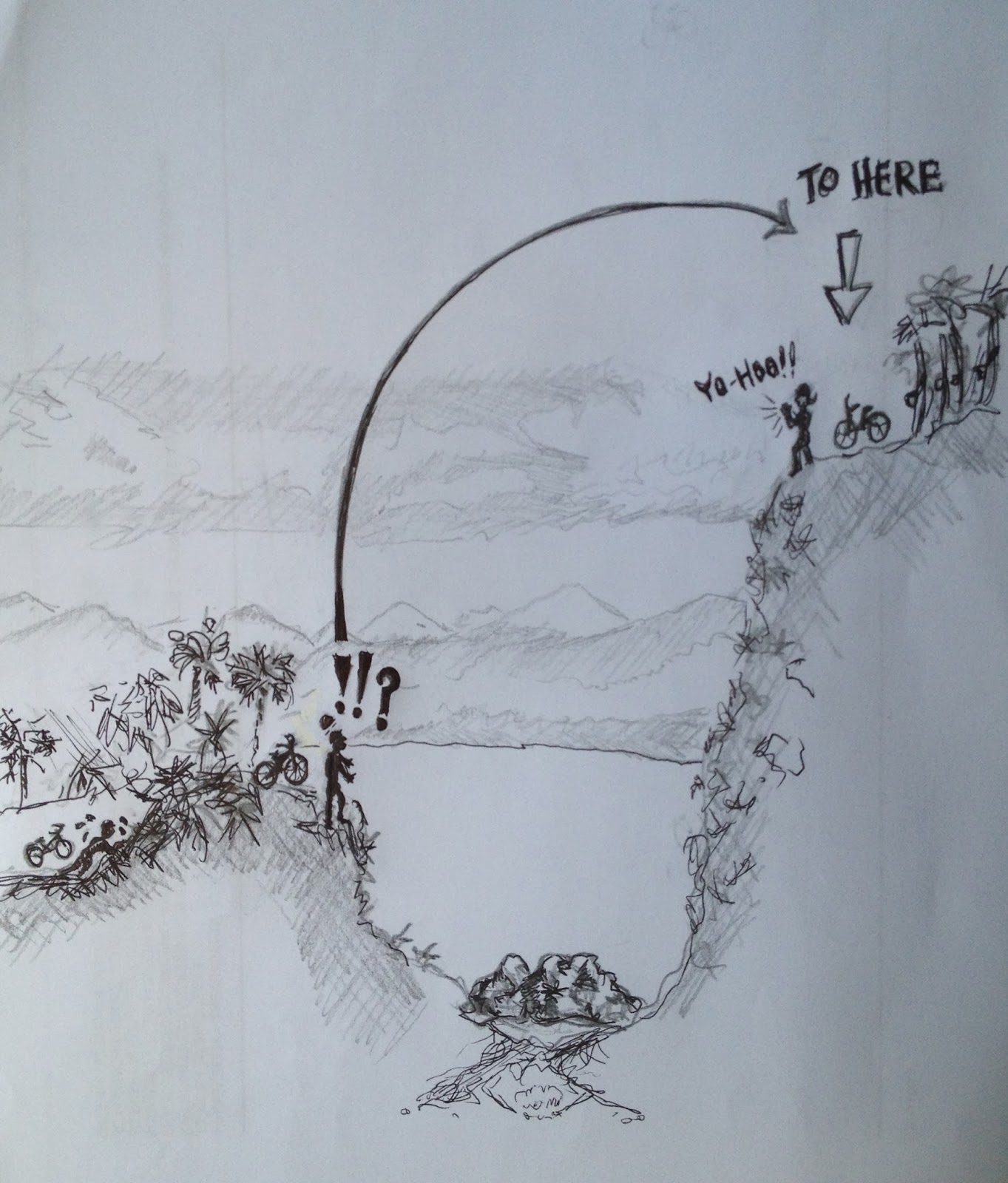

Pic 5 : OMG !!

From the bottom of the "ravine", I saw three columns of riders (one to my left, one in the middle and the last to my right) trying to climb the steep slope.  Each column of riders were climbing the slope across the ravine with their bikes in tow.  A Marshall was there and I asked him which route was the easiest to ascend.  The Marshall advised me to go for the option to my left.  Other riders must have decided not to wait in line up the slope via the easiest route (to my left) and had decided to try to cut the waiting time by ascending the slope via another route.  I stood there cursing to myself, “This is not a MTB ride! This has turned out to be a “cross-country lug your bike up the steep slope” ride.  


After assessing the options, I went for the right most option as it had the shortest queue.  I carried my bike down the slope to the river bed. We still had to wait in line.

 After waiting for a few good minutes there was still no progress.  I decided to turn back and joined the queue using the easiest option i.e. to my left.
Pic 6 "Soldiers” climbing down the slope to the bottom of the river "ravine" on one side


The good thing about this particular challenge was that you could see the riders helping each other ascend the slope.  One column of riders had formed a chain and helped to carry their bikes up the slope first before climbing up slope.

Next to me were a few female riders and they were to have a difficult time climbing up the slope with their bikes.


Pic 7 below shows the steep slope on the other side of the "ravine" where we had to climb up  
 
Pic 7: Steep slope on the other side of the ravine


 Pic 8:This shows a zoomed in view of the Pic 7 (near the top) showing the “soldiers” with their bikes in tow. 


The two pics (Pic 7 and Pic 8)  would give one a reasonably good idea of the scale and size of that #%#@ slope where we had to lug our bikes up.  Pity the guys with full-sus bikes and the ladies.

Just before CP2 where I was cruising downhill, I witnessed an accident.   I saw a cyclist lying down and bleeding from the knee being attended to by another cyclist.  A Medic had to bring a stretcher with him from CP2 to the accident site.  An ambulance was on stand-by at CP2 but the injured person had to be carried out.  Luckily the accident happened not far from CP2.  I was thinking to myself that it would be good to have an ATV to drive in but alas the trail was too narrow for an ATV.   We were all walking in single file to CP2.  There was the usual jam as it was a single track trial.

I had finished 1.5 bottles of my water.  I took the opportunity to refill my two water bottles and gobbled two bananas.  True enough, coming up to CP2, I overheard one female rider’s conversation with the Marshall.   She was throwing in the towel.  She said that she could not go on and opted for the chicken route.  The killer “hike-a-bike” slope did its toll.

I noted the time on my watch, it was 5 minutes to 12:00pm.  The Marshall said that he was closing Loop 3 in 5 minutes.  I then realised that I was mistaken in thinking that the cut off was at 12:30pm. I was surprised at how long it took me to complete Loop 2. The steep hill climb and the ravine were to blame.

Loop 3 (17km)
The sun had finally come out to play and it was getting hotter.   I began to slow down and was feeling hungry and tired.  I took out the power gel.   I had asked Edward to help me buy caffeine free power gel.  It was my first time trying power gel, it just tasted very, very sweet.  I continued my pushing the bike up the steep slopes and thankfully cruising down the descents.  This seemed to continue on and on….

Another “pleasant” obstacle that the organisers put up, again reminded me of a “war zone.  We were cycling in secondary jungle but out of the blue there was a clearing we had to cycle through.  This time the whole ground was littered with fallen tree logs. 

Pic 9:  Another war zone
We again had to carry our bikes over the closely spaced fallen logs. I wondered if any gung-ho cyclist tried cycling over the ground of logs? Perhaps the guys on 29inch MTBs?

As the organisers mentioned in their notes, Loop 3 was a mix of everything.  It went through oil palm estates, rubber estates and secondary jungles with good jungle canopy cover.  There were uphill climbs and descents also.  Heck, there was even a river crossing to wash and cool down.  I think I cycled through about 3 river bridges, ranging from small crossings made up of a few logs tied together to a huge metal plated/concrete  bridge.

I was getting tired, hungry and weary.  I finished my two power bars and was soon running low on water.  The two 750ml water bottles were not enough.  On one stretch, in the rubber plantation two riders suffered cramps at approximately the same spot.  I had stopped and was resting near that spot.  The whole area was a nice shady spot to rest.  One rider had the cramps and fell to the ground, the other just stopped and could not move.  He remained stationary unable to get off his bike.  One of the other riders had to stabilise his bike and slowly helped him get off his bike to sit on the ground.

Pic 10 : cooling down by the river
It was getting hot and a welcome relief to some of riders was when we came across a stream.  The stream was wider and deeper than the first one in Loop 1.  I was advised by the old rider whom I met (see Riders Section at the end) to carry my bike and not wet the gears.  I stopped, secured my phone and wallet in the water proof bag and waded across the stream carrying my heavy bike.

Some of the bikers were really enjoying the cool water and were casually floating about in the water.  I too was tempted to just stop and enjoy but decided against it.

We cycled on and came across another scenic rubber plantation and lake. I had to stop to take a pic.


We had completed about 11 km when we came across a group of Marshalls.  They were there sweeping the area for stragglers and it looked like I was one of them stragglers (ha-ha).  The four of them gave us two choices.   One to take the long way back to the Fish farm but via road or take the “last” hill and cycle through some scenic areas.  At that time I was thinking of taking the easy way out i.e. “hit the road Jack”.  But they advised us that since we have cycled such a long way we should  take the last hill and cycle through the “enchanted forest”.


Pic 11:  scenic rubber plantation with lake in the background

Pic 12 : black & white rendering of pic 11
So on we went the last group. Pushed the bikes up the last hill (so we thought).  We went up that hill and cycled for a while before we came to another hill to climb.  Oh No!!  Couldn’t believe it!  We fell for the old  “last hill left to climb” routine.  It was at this point that I was thinking it was a better idea to take the easy flat road back to the Fish Farm.

Anyway we trudged along and from my conversation with the young rider next to me this PCC ride was his first ever ride on his brand new MTB.  He had just bought it two weeks ago and had only cycled his bike around the house. What a good introduction to MTB this was for him.

After that second hill, it was all downhill and I whole heartedly agree with the Marshall.  This section was GREAT MTB cycling country!!!  We passed more jungle and plantations and the most amazing part of this section was a short length where there were only two rows of perfectly line trees that we cycled through.  The Marshall described this section as the scene in the Korean TV series, “Winter Sonata”. 
Pic 13: What I found that resembled the path I cycled through.


My greatest regret was, I did not stop to take photos.  DANG!!  I rushed through the section as I was running out of time and my phone battery had died.  I brought a power pack but the connecting wire was damaged, so in the end – no power to my hand phone and hence no pics. I totally forgot about my other point & shoot camera in my back-pack.


Finally we came out of the trail and into CP3.  The time was about 3:45 pm.  I downed one full bottle of mineral water from the CP3 attendee.

I had ran out of time and had to get back to the fish farm.  I cycled the last 6.5 km on the road back to the Fish Farm as fast as I could. I got my second wind and was pedaling as fast as i could.......


to be continued....

Friday, November 29, 2013

Sepang Jamboree 2011

Date    : 11th December 2011
Venue : Sepang International Circuit (SIC)
Time    : 0700-1430 hrs
Jamboree Route around SIC

Jamboree Route Elevation & Distance

The Beginning
On the 11th Dec of 2011, I took part in my first Mountain Bike(MTB) Jamboree. I took up MT Biking in March 2010 where the three of us friends bought the same Mountain bike together from the same store. It has taken a while before I finally decided to participate in a Jamboree. The following is a brief account of my participation in my inaugural MTB Jamboree, Sepang Jamboree 2011.

Pre -Race training
The actual “intensive” training that I did was done 3 weeks before the actual jamboree. My cycling buddy and I  cycled up Bukit Dinding in Taman Setiawangsa. The distance from the entrance to the top of the hill is 2.5 km and it is 100% pure uphill cycling.  We would go up and down the hill twice per visit.  All in all we went up Bukit Dinding every weekend for three weekends preceding the Jamboree.

Early morning Fright
Got up at 6:30 am. The previous night I had already prepared all the attire and attached the bike rack to the back of my car. I set off at about 7:00 am thinking that it would take me about 45 minutes to reach my destination. I had printed out the directions to SIC using Google map and printed out the route in detail on several A4 sheets of paper detailing every road turning. As it turned out the roads in Google map was not updated and from Dengkil onwards I was lost. In the end I had to rely on the road signs to lead me to SIC.  I reached SIC later than planned at about 8:10 am. The Jamboree was planned to kick off at 8:30 am.  Now I had another problem, I could not find the actual meeting place (car park) as there were so many car parks in SIC.  I spotted another Kancil who was also lost.  Eventually we asked one of the personnel in the car park and thankfully he knew about the event and gave us directions to the location. Another couple of tense minutes of driving around the SIC, we found the correct car park and there was already a big bunch of cyclists waiting in anticipation at the starting line.  One of the female organisers told me to park my car beside the road, quickly register and then to drive to the designated car park area.  I ran in to find the registration counter.  Once done I ran back to the car with my goody bag and proceeded to drive to the car park which was about another 150 metres away.  I busied getting my bike off the rack and got myself changed for the race.  I quickly strapped my participant number on to the front of my bike and cycled to the starting line.  At this time the crowd of cyclists had built up and I was way towards the end of the starting pack.

PreRace Briefing
I had missed the pre-race briefing and in my haste, I had left my mobile phone and camera in my car.  I was thinking to myself:  “My first MTB Jamboree and I had no way of capturing the events for rememberance”
Waiting for the start of the "race". Me (in orange) with Edward
(in black) and his son (in red & white) in the centre of pic

Starting Line.
It was at the starting line that I finally caught up with my cycling buddy, Edward and son who had taken the tolled highway to SIC.  I quickly asked about the salient points from the pre-race briefing.  My buddy answered that the mobile phone numbers of the persons-in-charge at the three checkpoints were printed behind our participant number.  We were supposed to call them if ever we got lost. “Great! I left my mobile in my car, so the emergency numbers were of no use to me!”
And we are off!
There was a short delay as the organizers were waiting for the arrival of the superbikes to lead the start of the Jamboree.  After a short wait the “race” got started amidst sprays of colorful glitter and paper from the handheld tubes shot up to the cloudy and windy morning sky. “What a fantastic day for a Sunday morning ride!” I was thinking to myself while waiting for the start of the Jamboree. The sun was hidden behind the clouds and there was a constant cool breeze.  I pushed forward from the back of the pack such that I was in the middle of the pack. I thought to myself, better not be at the back of the pack just in case I get lost. At least there would still be cyclists whom I could follow. It was a wonderful experience as hundreds of bicycles thundered along the bitumen road.  I meant it when I said “thundered” along the road as you could hear the loud sound of the bicycle tyres as they scrambled down the bitumen road.  I kept pushing hard to get as far forward as I could as I was anticipating myself to slow down after the second check point.  It was rather difficult as there were so many of us. After a short ride on the road we were in the oil palm estate trails.

First Check-Point (14 km)
Pic of me in background coming out of the oil palm
trails towards the first Check point (I think)
The ride was quick and challenging with a mix of short uphill and downhill trails. But there was a rather long uphill climb towards the end of Check Point 1. This was where I had to stop and pushed my bike up. Earlier I told myself as far as possible not to stop to rest and while going downhill to pedal hard to take advantage of the downhill and momentum. I found myself not following my own advice on the downhill as I was already tired after the uphill climb. I would just let the bike cruise downhill without pedaling.  I told myself to just keep moving and to try as much as possible not to stop to rest. Worst come to worst just get off the bike and push it. As I progressed I noted that there were a lot of sharp turns especially after the short downhill stretches.  On two occasions I saw riders overshooting the turns as they were coming down too fast.
We cycled out of the oil palm estate and onto a highway. We rode beside the highway against traffic and then turned into the dirt trail where we reached the first check point.  It was a relief to see the first check point. I got my colored validation sticker pasted onto the participation number and continued on to the second check point.  “Okay, first leg done, another 2 more legs to go!”  It was at this point that I started wondering how my cycling buddy and his son were doing.  I did not see them since the starting line.

Second check Point (14 km)
Into the oil palm trails again we cycled.  Soon after the first check point there was another tough uphill climb. I too had to get off my bike and pushed my bike uphill.  Somewhere in the middle of the ride, we encountered a group of riders and they were saying that they got lost and could not follow the road signs nor the shredded paper trail.  The riders were confused. After a brief moment we just pushed on ahead and hoped for the best. Luckily for us we did not get lost and reached the second check point.  To reach the second check point again we had to cycle on the highway against the car traffic. This time the ride on the highway was a lot shorter.  It was towards the second check point that I felt extremely hungry. My stomach was beginning to complain.  I did not take the Power Bar that was supplied to us in the goody bag.  In fact I did not even notice it as I was rushing to the starting line.  Here I was hungry and tired in the middle of the oil palm estate. I told myself to push on to the third check point.
Past the second check point, fewer riders could be seen by me. Whenever the riders passed, we would give words of encouragement.  It was here where I started complaining to the riders passing by that I was hungry and tired.  Most of them also complained that they were hungry too but one lone rider who was passing me stopped his bike and offered to share his last power bar with me.  It was a great relief as I could now munch on something.  I said to him, “You are a life saver man!”  We stopped to enjoy the power bar, we introduced ourselves and he then sped off after he had finished his half of the power bar. (Thanks Faiz!)

Third Check Point (9 km)
After that short fuel stop, with some additional energy in me I continued cycling to the third check point. I got the last colored sticker and I told myself, “Thats it, I am almost there! The tough uphill climbs are over. I am home free! This last leg is mostly downhill!”  With the encouragement from the organizers at the last check point,  I pushed onwards .
Queing up for grub after the lucky draw. At the
white tent in the background there is also a long
queue lining up for their turn in the lucky draw
The Finish Line
Finally I was onto the bitumen road and the last stretch was really good as it was downhill all the way to the finish line. Once I reached the finish line, there was a long queue of riders lining up to try their luck at the first lucky draw. I only managed to get another Power Bar. After that we headed to the buffet tent where everyone was also queuing up for the buffet lunch. Its incredible how delicious the food tasted especially when one is absolutely famished. It was only after I had gotten my plate of food and was almost finished with it that I saw my first glimpse of Edward.  I called to him and asked what had happened.  He told me his son had a tough time on the course and he had to wait for him.


The Lucky Draw
After lunch, we washed our bikes at the bike wash area and then we took a quick rinse in the toilet. Edward and his son went home early as his son was extremely tired and needed to rest. (Edward said that on reaching home his son made a beeline for his bed and slept.) Then came the main event: The lucky draws. Everyone was relaxed and in a jovial mood in the car park and of course hoping that luck would be on their side to take home a lucky draw prize.  There were heaps and heaps of lucky draw prizes given away that Sunday afternoon.  I can say that a lot of people got a lucky prize be it big or small.  Of course everyone was eyeing the Grand Prizes of mountain bikes and bike frames.  I was aiming low and was hoping to win the Cateye hybrid headlight (solar/battery). After the last grand prize of Specialized FSR Bike Frame (worth RM4,862) was given off everyone dispersed and headed home.

I think I speak for all who participated in the Jamboree.  It was truly a feeling of a great sense of achievement as I reached the finish line. Take part in the "race" BUT do not over exert yourself was the thought at the back of my mind throughout the event and lastly, to try not to get in last (hee hee).  Everyone who completed the course got a finisher medal.  Thus ended my first ever Jamboree.

Pic taken in one of clearings heading towards the first
check point (I think)
Post Race
The next day I frantically searched the web for pictures of the race and luckily found some photos of me in them.  So it was an added bonus to find photos of me to keep for the album too. Yay!

I also found out later that week at work, that the winner of the grand prize Specialized bike frame was my colleague’s younger brother who had just recently started mountain biking. Lady luck shined on the “newbee” that Sunday afternoon.

Wednesday, November 20, 2013

Kemensah Trail May2010

Location:   Kemensah Trail
                   Jalan Taman Zooview, Kuala Lumpur

Behind the Zoo Negara along Jalan Ulu Klang is a fairly large area of forest. This area is part of the Klang Gates Dam catchment area. This area has several jungle trails which are used by MTB, hikers and ATVs.


Pic 1 (right)-Two mountain bikers chatting while bathing in the sunlight at a clearing along one of the trails.


Pic 2(left) -Early morning sunburst through the trees along Jalan Taman Zooview.


If you were to cycle along Jalan Taman Zooview pass the back of the zoo, the road leads to an area where mountain bikers traverse into the forest and catchment area.


Jalan Taman Zooview will eventually lead you to Taman Ukay Perdana where unfortunately rapid development is on-going.  Hence in a couple of more years this little forest delight will be lost forever?

A mountain biking enthusiast said that in the 80s , one could cycle along Taman Zooview and see early morning mist. Alas not anymore. The river that runs along the road could once be used by residents in times of drought or water rationing.


How long will this beautiful and fresh green area last?........ It is up to you the people and residents to decide......

Pic 3( below-right)
This is one of the ponds along the off road trail into the catchment area


Pic 4 (above left)
Morning sunlight through the forest canopy


    Pic 5 Early morning mist rolling across the valley after a night of rain

Wednesday, November 13, 2013

Kemensah Trail - One Sunday Morning (circa 2010)

One Sunday morning along Jalan Taman Zooview, Ulu Klang, Kuala Lumpur, Malaysia, behind the National Zoo (Zoo Negara)


"Hey Honey! "
"Guess who we met when we were out cycling this morning on Jalan Taman Zooview? "


"Hey Honey! Guess who we met when we were out cycling this morning?"
A brilliant bright light descended upon us at Jalan Zooview.

 We made an about turn to try to run away from the bright,flashing light...
It came after us!!


As hard we could pedal, we were not able to run away from it  :-(


the next thing I remembered, I was off my bike.....
..and was lying on the cold hard jungle ground with the warm sunlight shining down on my face


To be continued.......


Footnote: Sadly the bamboo growth has been trimmed down and one will not be able to take the same photos again

Early morning sunburst through the bamboo foliage @ Kemensah


Sunday, November 10, 2013

Broga Reverse 116 - the longest ride

BROGA REVERSE 116: - THE LONGEST RIDE

Event: Broga Reverse 116
Date: 9th December 2012

 Introduction:
This event was the first time I attempted to cycle non-stop on the road a distance of 60 km on my MTB.  Most of the distances I had done were in the range of 20-30 km only. I had done a few 50+ km rides from to home to Ulu Langat-Bukit Hantu and back home but not a continuous ride of 60 km.  I had also upgraded my MTB from the Raleigh Diablo to a Fuji Tahoe 1.0.  I already knew that I would not have the stamina to cycle 116 km on my MTB and therefore opted for the “old-man” option of 60 km. That 60 km distance category was meant for foldies but, what the heck!  I had wanted to attempt this “long” distance ride and so I had to swallow my pride and joined the foldies category but using my newer and lighter MTB.  What an unfair advantage for me, you would say.  Nevertheless during the actual event many foldies “out- rode” me on my MTB  (so sad and pathetic) .
I stumbled upon this event on Facebook. There was a call to cycle in the Broga area.  Broga was familiar to me only as a hill to trek to see the sunrise.  I have heard that Broga is a very nice hill to climb, located South of Kuala Lumpur, Malaysia, somewhere near Semenyih town.   Cycling buddy Edward and I read about it and decided to join the group of cyclists who were going to cycle in Broga.  We met the group without knowing anyone on that Saturday (4 Nov 2012). From there we heard about this Broga Reverse 116. I decided to take part in the event while Edward declined as he was not available on the day of the event.
It was there that we met the organiser Elaine Wong and another cyclist Jimmy Chow from Ori bike shop with the rest of the Ori foldies bike members.

The trial rides
There were two trial rides. The first one (4Nov 2012) was with Edward. We had to abandon the ride one third of the way. The trial ride was meant to start early at 7am.  But by the time we set off it was past 8 am. Both Edward and I had always started our rides early in the morning. This was deliberately done to avoid the hot sun later in the morning. On that day the sun was really hot and both of us decided to abort the ride at about one third the planned distance. We backtracked the way we came and managed to get back to the Police Station meeting point.

Pic 1: The gang of enthusiasts wanting to do trial run.  Majority were foldies (4 Nov 2012) . As usual double click on the photos  to get a zoomed in view


I was on my own for the second trial ride (2 Dec 2012). By this time I had already registered and paid for the Broga Reverse ride.  The meeting place was at the same place as the first trial run ride (Police Station at Taman Tasik Semenyih).  This time I managed to complete the whole course. It was tough especially towards to end as we had to climb up past Broga and up the hill towards Nottingham University.  I had to deal with the extra-long ride plus the intense heat of the sun as it was approaching noon.
It was a satisfying trial run as I managed to complete my first long 60 km ride.  Yay!!   
Nevertheless I was humbled by a foldie who was riding with a fixed gear. He passed me along on the return leg to the Police station (Hiss! Hiss Edwin! ha-ha).  Elaine reminded the gang to attend the Goody-bag and pre-ride briefing which was to be at the VW showroom along Sungei Besi the same evening.

Pick up goody bag and Pre-ride Briefing (2nd Dec 2012)
 Pic 2: Early goody-bag pickup and pre-ride briefing location
I had not planned to go as I thought that I would be tired after the morning’s trial ride.  Anyway it rained that evening but I eventually found my way to the briefing.  There I was pleasantly surprised that there was a picture of me in one of the presentation slides.  It was to warn the riders of the speed bumps that were installed on the road. They were told to be aware of it as it was at a downhill stretch and the riders were to slow down before they encounter the speed bumps else they may fall over.  It 
was by pure luck I was cycling down that stretch as the photographer was taking a picture of the speed bumps. (Yeah.. right! Hehehe)
Footnote: Not many riders turned up for the briefing. I supposed it was partly due to the spell of rain earlier
 
I guess by now you would have realised that VW was one of the sponsors of the ride.

Event Day
I got to the University of Nottingham early without any hitches as I was familiar with the route.  There I met some of the Ori-bike gang from the earlier trial rides. I noted that they were the best organised team. They even had a support van that came along both during the trials and on event day. Heck! They even had their own private photographer taking action shots from the van as the riders rode along the route.  I also met a colleague who was going to participate in the full 116 km event.
I had already collected my race jersey and race number on the afternoon of the 8th Dec at Nottingham University.
The ride was delayed as the organiser was waiting for a VIP to turn up. In the end we started out without the VIP sending us off.
Pic 3:  View of participants at starting line


I told myself to keep pace with the bunch of Ori riders. Initially I was glad I was ahead of them. But eventually everyone of them effortlessly passed me by.  Sigh!! Overtaken and out-paced by foldies.   :-(
Pic 4: Ori Riders at the start line


The ride on the whole was  good and uneventful.   I did not push myself and just cycled at my pace, hoping that my left knee will not start complaining.  I remembered being passed by the “professional” riders as I was riding towards Broga hill on the return leg.  The police motorbike outrider was escorting the first batch of the front cyclists.  (Dang! They were cycling at more than twice my speed as they were doing the 116km while I was doing the 60km route. How embarrassing.)  Just right after Broga hill and as I was climbing up the slope towards Nottingham University, my colleague from work was the second batch of “professional” riders who passed me.  Triple embarrassment it was!  

Pic 5 : Start of the long ride with the sunrise over the horizon

The lunch that came in plastic lunch boxes was not worth mentioning. There were a lot of lunch boxes left as I guessed most of the bikers did not stay for the lucky draw and the prize giving ceremony. I was terribly hungry and had a second helping.
The weather turned for the worse and it started to rain. So we had to switch the prize giving ceremony and lucky draw indoors.
Pic 6: Location of awards ceremony. Rain forced it inside the building
I supposed the “negative” aspect of this ride was that there were complaints of cheating.  Allegedly in the female category the person cheated. The organiser had called upon the person to come forward to clarify but she did not show herself.  By default she was dropped from the winner’s list.

There were plenty of lucky draw prizes that day too.  Alas, in the lucky draw, I won a travelling bag.  As it was getting late, I then decided to call it a day and drove home. 


Sub-story 1 : There was a last minute route change to the 116 km route as there was a landslide on the original route. (the road along the Semenyih dam.. another story for the future).  As such the organiser had to come up with an alternative route. The new distance for the alternative route was shortened to 105 km.

Sub-story 2  : Having joined Elaine Wong for two trial rides, KUDOS must be given to her and her team for organising this ride.  Elaine was on her bicycle constantly checking and testing both the routes personally.  If it was me, I would have taken the easy way and used a car to recce the routes.  Not her, she actually cycled the routes.  A rather interesting and alarming story from her was this: On one of her recce rides, she had two punctures and to add salt to the wound it poured heavily. They had to abandon the ride. While waiting for her buddy to get the car, she stopped under a bus stop for shelter from the cold and rain.  A motorcyclist stopped and flashed her and began "amusing" himself. (tsk.. tsk.. there are many sickos out there). Female cyclists be on the alert and cycle in a group.  But the silver lining to this story was that a kind and concerned motorist actually stopped by to offer her help while she was waiting for her buddy to pick her up. (Yay... there is some goodness out there !!)

Pic7: Broga Ride Route Map : A measely average speed of 19 km/h

Pic 8: Broga Ride - My Profile

Friday, November 8, 2013

Kemensah Trails- Lake Views

 Kemensah Trails- Lake Views

The MTB trails in Kemensah can lead to the shores of the Klang Gates Catchment Lake. These series of photos highlights the views from the side of the huge lake formed by the Klang Gates Dam in  Kemensah.
Photo 1 : Lake view - Date: May 2012


Photo 1 is a favourite shot of the lake. The water surface is so still that the picture can be viewed upside down


The lake as can be seen in Photo 2 is huge.

Photo 2 : Google Map of Klang Gates Dam forming the huge catchment Lake
Photo 3 : Panoramic view of the lake shore. Date: 2011


Photo 3 is a wide panoramic view of the lake taken from the same location taken on a different date with different natural lighting


Photo 4: Date: 2011
Photo 4 is a shot showing the opposite shore of the lake taken from the same location as Photo 1 but on a different day. This time it was cloudy and the lake surface is not as still as the wind was picking up.


Photo 5 The stillness is so serene...
Photo 6 ...one can sit here and contemplate


Photo 7  Fancy a boat ride? Date: May 2012


Photo 7  shows an overturned boat in the background. We also picked up a homemade oar on the ground.


Photo 8  Date: June 2012
Photo 8 is not taken at the same location as the earlier pictures. This was taken at another part of the lake. The location of this place is South-West of the earlier location.   A clump of sparsely spaced bamboo was growing on the lake edge. One can see the brightly reflected lake surface through the bamboo growth.

Photo 9   Date: June 2012
Photo 9 is taken at the same location as Photo 8.  It was taken at a clearing to the left of the bamboo growth.


Footnote : double click on the photos for a larger zoomed in view
  *** "take nothing but photos, leave nothing but footprints" ***


The video below is a short take of the lake area