Monday, May 12, 2014

Around Penang Island -Where2Go Ultimate Challenge May 2014


Event:                   Where2go Ultimate Challenge 2014
Date :                    Sunday 11 May 2014
Location :             Penang Island
Distance:             81.45 km (on my Apps and not 84 km as advertised)

The following is a brief account of my FIRST cycling ride around Penang island done on the 11 May 2014.  This event was the Where2go Ultimate Challenge.  The route was a clockwise route around Penang Island.  The Funkier group had a major turn out of 12 persons who signed up early this year for the event.  Some of us car pooled to get to Penang from KL. Some drove up themselves due to work schedule.

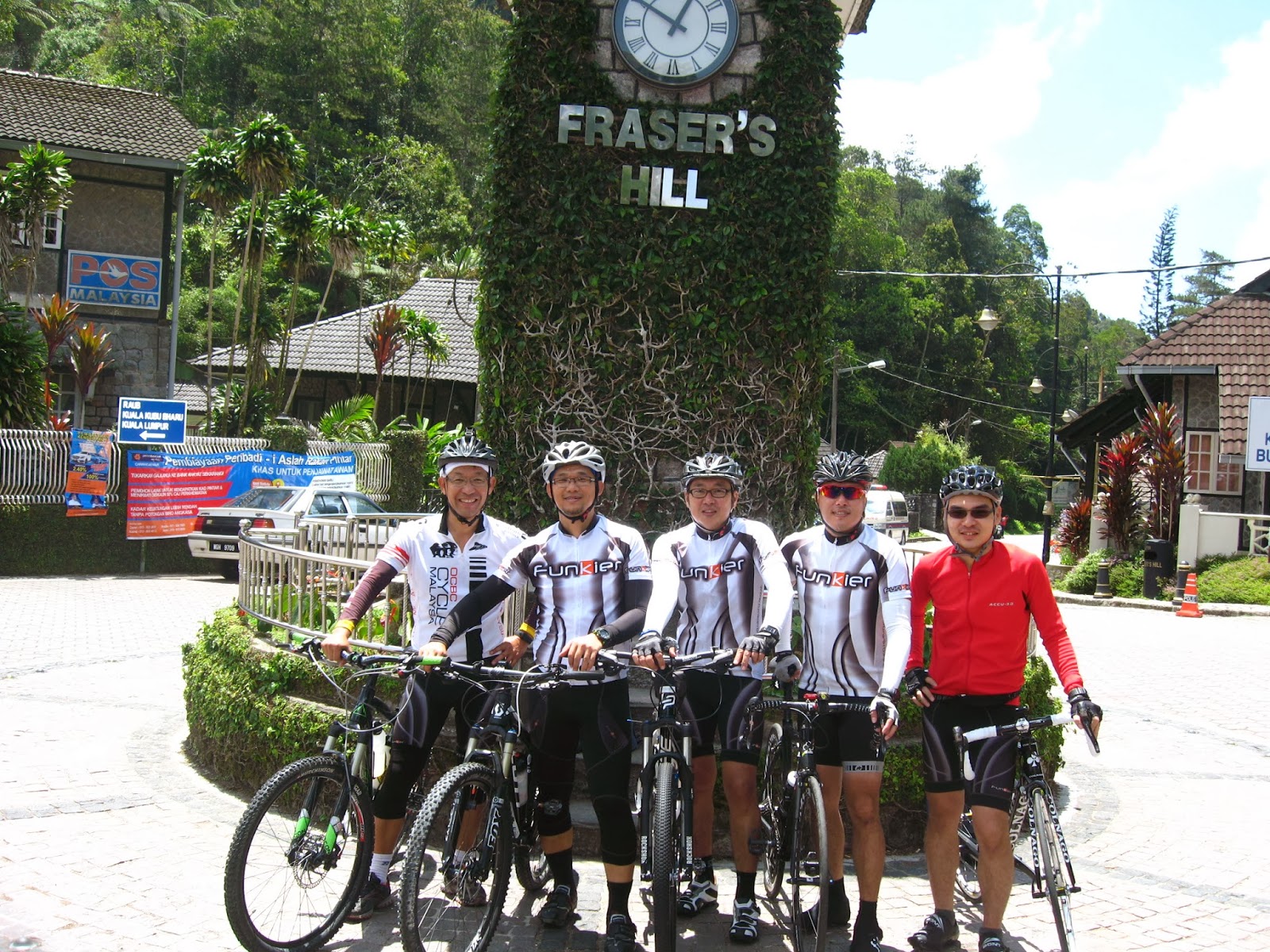
Pic No 1:The funkier group at the front of the hotel
The drive up to Penang will take about 4 -5 hours depending on each individuals’ drive speed.   I hitched  a ride from Edward’s car together with Ernie in his BIG Nissan X-trail.

Thanks to Sam who blocked booked us at the Bayview hotel which was less than 2 minutes cycling from the starting point at Padang Kota Lama.

We arrived at the hotel/goody bag pick up point early at about 3:30 pm on Saturday a day before the event.  We retrieved our goody bags at the hotel and and checked into our rooms. After which we went searching  for the famous Penang  Cendol, Assam Laksa and Rojak on Penang Road just next to Joo Hooi Cafe.

Preview
My initial estimate based on my average speed in Ulu Langat hills,Selangor of 20 km/hr meant that to complete 84 km it would take me 4.2 hrs of continuous cycling.  But that duration discounts stoppage time for picture taking and pit stops.  So I estimated that it would take me 4.5 hours to complete. That meant that I would not meet the cut-off time of 4 hours.

Also I thought that I would need help to ensure that I had enough energy to ride continuously for that long a duration.  So this time I decided to use external “scientific” help i.e. get some power bars/gels and rehydration salts. The first time I tried the power gels was during the 2013  PCC MTB event.  I didn’t like the taste of it.  It had tasted extremely sweet.  Anyway this time I decided to get some again.  I also found out that I had to drink 250ml of water after eating the power gel. That made sense to me as it was so, so sweet that one would have to wash that sweet taste off with water, plenty of water.

So for the Where2go Challenge, I was more prepared against getting hungry and cramps.  I had power gels and rehydration salts to assist me.

The Main Event
Pic No 2: The stating line.  Waiting for the start of the event. Edward can be seen with his expensive sunglasses
We were early and we managed to get near the starting line.  As usual the photography sessions by the partcipants were going on while waiting for the start of the event. We were hoping that it would be cloudy with light showers in late morning/early noon.  Our journey to Penang the day before was very wet with heavy showers.

Pic No 3: Second Penang Bridge
The start of the event was uneventful. The event started off with the blare of the horn.


I  cycled about 15.4 kilometres  and stopped to take the first pic of the ride. The orange sign in pic No 3 on the right says “Penang 2nd Bridge” and in the background as per the sign is the newly completed Second Penang bridge.  The bridge started operations in January 2014.


The first major climb of the ride is shown in picture no 4 below, one can see Bandar Baru Teluk Kumbar (Located south of penang island) in the background and the winding road from the right of the pic climbing up to the point where I took the picture ( at approximate KP 29.0)


Pic No 4: The first (1st ) major climb of the ride (approx 29.0 km)
After that climb it was a pleasant downhill ride on to flat elevations of riding through the country side.

To prevent myself from dehydrating and getting cramps I had taken a bottle of water at every one of the 4 water stations. That meant that my bladder was filling up.  So it was timely that I found the pit stop at the Jalan Sg Rusa/ Jalan Pantai Acheh road junction at KP 47.3.   A lot of the riders stopped at this point as it was the beginning of the second climb up the Balik Pulau hill.  The coffee shop there was doing a roaring business that morning.  I parked my bike in front of the temple next to the coffee shop and used the coffee shop’s toilet.

Pic No 5: Pit stop at 47.3 km
Pic No 6 :Temple next to coffee shop

From this point onwards the second major climb of the ride awaits. This time the climb is more gradual but it covers a longer distance.  This section of the ride in my opinion is the best part of the ride.  The temperature here was cooler  as the side of the hill helped to block part of  the morning sun at certain stretches of the road.


The second  major climb of the ride is shown in the picture No 7 below. The winding road can be seen at the bottom right of the picture( in the background) . The road  climbs up to the point where I took the picture ( at approximate KP 49.0).  Contrast this 2nd climb (Pic No 7) with the 1st climb (Pic No 4). There is so much more shade and trees making this section much more comfortable to ride.


Also one can see plenty of durian trees with the fruits about to ripen. The owners have actually placed nets just above the ground to catch the falling durians and prevent them from rolling down the hilly slopes.
Pic No 7: The second (2nd) major climb (at approximately 49.0 Km)
Pic No 8 : Durians, Durians Galore (top of pic)
There were plenty of durian trees growing on the slopes of this stretch of the road.  As usual place your cursor on the pics and click for a zoomed-in view.

Pic No 9 The climb looking uphill
I also remembered passing a waterfall picnic area, Titi Kerawang waterfall at approximately KP50.4 km

About three quarters up the climb, there is a lookout point at KP50.6.  This is before the Tropical Fruit farm.  A lot of the riders chose to stop to take a pic there and to rest.  I managed to get a rider to help me take the pic below.  He too stopped to take a pic of his young son at the same spot.  Father and son bonding ride for the weekend.

While coming down the hill, I spotted a house with a sign on the fence “Home made assam laksa”. I was curious and wondered who would stop at this remote spot to eat.  I also passed a durian stall along the downhill stretch. Plenty of durians for sale there waiting to be eaten.  

Pic No 10 Lookout Point (50.6 km)
While cruising downhill when I first caught a view of the Teluk Bahang Dam, I made a mental note as I thought the reservoir was too close to the coast line.  On checking with google map later I found that the edge of the lake was only about 2 km away from the coast.  So I was right! (after all Penang is a small island, I suppose).  The water level of the dam was also not full as I noticed the lake’s water level to be below the treeline.  So the recent drought and water rationing in Selangor is not confined to Selangor alone.  Penang also experienced a drought. Also passed  a butterfly farm at Teluk Bahang.

I noted the remaining time and told myself that I had to minimise or cease my picture taking stops.  I had to try to make it within the 4 hours cut off time.  So in the end, I did not take pics of Teluk Bahang Dam, Butterfly Farm, Titi Kerawang Waterfall sign, the assam laksa house/restaurant and the durian stall.

The last leg of the ride along Batu Feringgi back to Georgetown was not particularly enjoyable as one had to cycle with the traffic along Batu Feringgi’s narrow and windy roads. Luckily it was a Sunday with less traffic(?).  There was an accident  at one of the hill side stretches involving a motorcar and a motorbike.  The motorcyclist was on the ground laying motionless as the police attended to the victim.  I did not stop as I was trying to make haste to reach the finish line.  It was getting hot and dusty with the addition of the buses, cars and motorbikes on the road.  As it was getting late, there were no marshalls to control the traffic at the traffic junctions unlike the early morning sections.  So one had to cycle at one’s peril at the traffic intersections.

Pic No 11: The clear view from the Lookout Point
I was glad when I reached Gurney Drive as I knew the finish line in Georgetown was very near. On reaching the the finish line, I made a beeline for the tent marked “FOOD”.  Saw the public toilet near the tent and went to the public toilet for another pit stop.  After that I lined up to collect my lunch.  It was only after I had eaten that I remembered the finisher medal.  I still did not know whether I managed to complete within the stipulated 4 hours.  Went to ask the organiser if the medals were still available and was told the medal counter was closed.  From my top of the head calculations, I estimated  that I had missed the 4 hour mark.  Texted Edward and he said that he was back in the hotel.  Anyway I went back to the hotel and got ready to check out as the hotel did not want to extend our checkout time.

It was only after we checked out when I had time to sit down on the hotel steps with the help of my Endomondo Apps that I was able to confirm my total time taken.

I had accidentally stopped my Apps when I stopped to take my first picture of the ride. So I had to start another file with the Apps.  Hence I have two profiles on that day. The first part was from the starting point at Padang Kota Lama heading south towards the second Penang Bridge which incidentally is not on the Google map. Google map has not updated their map of Penang. (From 0 km to 15.42 km )

Pic No 12 : Route details (part 1 of 2)
The second part was the remaining clockwise route back to the starting point (From 15.42  km to 81.45 km)

Pic No 13 : Route Details (part 2 of 2)

From my Apps record, my total time taken came out to be 0:30:58 + 3:37:50 = 4 :08:48  ie 4 hours and 9 minutes. (As usual place the mouse cursor onto the pics and click to zoom into the pics).  I came home “medal-less”  :-(   The rest of the funkier members completed the course within good time.

If one were not an avid cyclist, one would be thinking the following:-
Are u out of your BLINKING mind?!!  Are you going to drive 4-5 hours from KL to Penang the day before.  Ride 3-4 hours around the island and then drive another 4-5 hours back to KL on the same day?!!!”

But it was an experience I had to try and I am glad that my reply to the question: ”Cycled round Penang island?", would be a: "Yes been there and done it!”    

Now what I need is a nice 2 hours of full body genuine massage which I could not find in Penang island but that is another story………

Tuesday, March 4, 2014

Kuala Kubu Bahru,Selangor to Frasers Hill, Pahang

Event: Kuala Kubu Bahru,Selangor to Frasers Hill, Pahang
Date: 23 February 2014

The following is a brief description of my first bicycle ride up Fraser’s Hill.

The Funkier Bikerz Group had planned this trip way back in December 2013.  The plans were finalised when we were having Chinese New Year “yee sang” dinner in early February.  At the dinner there was a count of more than 10 who were interested.  This number dwindled as D-day loomed nearer.

The plan was to meet in KKB town at 7:30 am, have breakfast and start our journey at 8:00am. Have lunch up at Fraser’s Hill and then make our way back to KKB town in the afternoon. Target time back to KL was 5 pm.


Besides the trip being my first bicycle ride up Fraser’s hill, the journey also gave me a chance to take a trip down memory lane. When I first started working many years ago, I had to travel to Batang Kali as the developer whom I was working for, had a housing development there.  The site office was at a shop lot in Batang Kali. Every morning I would drive from KL to Batang Kali via Jalan Ipoh and Rawang town passing by Templar’s Park.

This early morning drive to KKB took me on the same route.  Rawang town has prospered and the roads to Rawang and KKB had improved and were wider.  I could still see the row of shops where my former office was located.

But KKB town still looked the same, quiet and peaceful albeit this Sunday, I noticed a lot of people. The small public car park next to the Post Office was bustling with hikers and cyclists.  

We started the ride started at about 8:20 am. I had a quick bite of “kon-low” mee to fill up the tank with carbo. The plate of noodles was nothing to shout about (perhaps it was because I was gobbling down the noodles in my haste).

The first landmark that we will see is the Sungai Selangor Dam just a few kilometres from KKB town.  One can see a huge formation of rocks in the horizon as one is cycling along the road.   The road leading into the dam's information centre also has parking spaces for cars.  I noticed a lot of bikers parking their cars there also.

We stopped at the dam for some quick photos at the information centre.  I remembered when the dam was being proposed, there was an outcry from some parties that were against the building of the dam. Anyway, be it good or bad for Selangor, the dam was built and completed in 2002.

Selangor had been experiencing a dry spell. (say what? ..drought in an equatorial country? ) This was very evident from what we witnessed at Sungai Selangor Dam.
Pic of dam and lake when it is full (taken from the web)
Pic of the same spot on the day


Panoramic shot of the dam and water depleted lake

The pic below was taken at the highest point where we could actually see the severity of the water
level of the surrounding lake. The waterline of the lake when full can be easily seen and it is here where we note the severe drop in the water level of the dam.
Lookout point overlooking the lake and dam
(A point to note: On the following Monday, Selangor declared that water rationing was going to be imposed.)

From the look-out point, the road slowly but surely  increases in elevation with the occasional dips in the elevation.  As I was cycling down the road, the remnants of a previous accident still remained. The heavily log laden lorry must have been speeding down the dip on the road. The road was curving up the dip and the lorry must have lost control and crashed to the side of the embankment

Twisted lorry laden with logs

The Sugai Chiling  Fish Sanctuary Park is the next landmark that one would encounter along the ride  to Fraser’s hill.

The entrance to the park is just after an old steel bridge.  That Sunday both sides of the road were filled with cars. There were a lot of hikers going into the Park.  I too found out later that this was also a good place to park your car if you intend to cycle up to Frasers. The road from this point onwards is very well shaded compared to the early stretch from KKB town to Chiling Park.

Sungai chiling entrance beside the road leading to Fraser's Hill
The road that morning was generally empty and the weather was cloudy. That made for a pleasant cycle up to the Gap. About 8 kilometres before the Gap there was a popular camping spot with a waterfall just beside the road. That morning a lot of picnickers were there cooking their meals

Popular waterfall picnic area just before the Gap
The picture of the waterfall was taken on the way down. I did not want to break my cycling rhythm on the way up. It was already late afternoon and the morning crowd had left. I noted that during that time, there were park workers cleaning up the early morning mess left by the morning picnickers.

The Gap is the last resting point before the final 8 km climb up to Fraser’s hill.  I was actually hoping to have a nice English breakfast at the Gap Resthouse. When I reached the place I was disappointed to find that the place was closed and in ruins. All the window frames were gone and the entrance was fenced up. What a disappointing sight to behold

The pic below was what I remembered the last time I took a trip up to Fraser’s.
The Gap Resthouse during its hey day right after its refurbishment
In the olden days before the second road was built for cars to come down Fraser’s, the Gap road was the only way up and down Fraser’s. The road is only a single lane road.  Cars going up and down Fraser’s hill had to share the road. One hour to go up and the following hour to go down.  It was odd hours for vehicles to go up and even hours for vehicles to come down.  There were caretakers to man the road barriers at the Gap and at the top of Fraser’s hill so as to ensure that vehicles were going up or down at the correct times.

The Gap Resthouse was a good place to have a snack and a toilet break while waiting for your turn to drive up Fraser’s Hill.  I guess once the additional access road was built, the Resthouse lost a lot of business as no one was forced to stop and have a snack while waiting for their turn to drive up to Fraser’s hill.
At the Gap junction- taking a breather before the final assault
Instead all I could find was a mini-stall to stop and recuperate before the final onslaught up the hill.

The pic below shows the current R&R spot. We could still get nasi lemak, mee goreng and canned drinks from the mini-stall.  A not so clean "pay as you use" public toilet is also available.

After a short refill and picture taking , the  two of us stragglers made our way up.


We had already found out on the mobile that the two road bikes had already reached the top.  Oh yes, did I forget to mention that only 5 of us eventually met up at KKB to cycle up Fraser’s hill that day? Two were on road bikes while the remaining 3 used mountain bikes.


View of the Gap road looking down -at about three kilometres from
fraser's hill
It took me a bit more than an hour to finish the last 8 kms.  This was when my old knee started complaining again. My right knee was giving me pain whilst my butt was also sore from sitting on the bike seat.  In order to relieve the pain from both my knee and butt, I decided to get off the bike and walk up the hill for a while

This gave me more time to stop and take more pictures as I was climbing that last stretch of the hill.


Looks like autumn along the road up from the Gap...but actually its due to a small bush fire scorching the plants and trees


Finally we made it up. The two road bikers and the one MTB(Ernie) had already eaten and rested. They had time to cool down such that they were starting to feel chilly from the rather breezy afternoon air.   Michael and I had our lunch at the open air café just next to the iconic Fraser’s Hill clock tower.


View of mountainside -about 2 kilometres from Fraser's Hill
After we satisfied our hunger, we had our group and solo pictures taken.  The most photographed spot at Fraser’s hill for cyclists…. The Clock Tower!

One most certainly MUST take a souvenir shot or two to show off to friends ... hehehe
Souvenir shot at the Clock Tower

The return journey was generally a relaxing downhill ride. The road going down Fraser's back to the Gap was generally in a poor condition as compared to the road going up. The road comes out on to the main trunk road leading to Raub/Bentong.  We actually had to cycle pass a concrete bridge built on the slopes. As we reached the main trunk road, there is also a "Fraser's Hill" signboard which is more noticeable for travellers coming from Bentong or Raub heading (i.e from the opposite direction)  to the Gap.


The downhill stretch heading back was generally well shaded except for the last stretch of road passing the dam. There is no shade and one had to cycle uphill back to KKB. This was a pain as one was already tired and hot due to the afternoon sun.

All in all the ride up to Fraser's was a good ride. Going up in the morning, one is protected from the sun as the hill offers shade to the cyclist right up to late morning.  It would be better to start the climb early and come back down before noon but that that means that you will have to come down immediately and that would  defeat the purpose of going up to Fraser's hill. The cool temperatures at Fraser's hill invites you to spend a bit more time up there to chill and relax.


Historical facts of Fraser’s Hill & its surroundings Ref:   http://www.fraserhill.info/index.htm

#TRIVIAL FACT No 1 :-
Did you know that Fraser’s hill was originally developed for tin ore mining?
Well I certainly didn’t !!  


The following were the statistics of the ride:
Distance :KKB to The Gap                         = 30 km
Distance: The Gap to Fraser’s Hill             =  8  km
Distance : Fraser's Hill to KBB                  = 41.7 km

Map of ride from KKB to Fraser's hill:
Note : there was a loss of GPS signal during my ride up : hence the “flat line”  from about the 1 hour to the 2 hour duration of my ride.

As usual double click on the pic for a large view

 Map of ride from Fraser's hill to KKB


The  Funkier Bikers ( left  to right: Michael, Ernie, Sam, Chris)


Thursday, December 26, 2013

Bukit Kiara Trail Ride 2011


Bukit Kiara Trail Ride 2011

Location of Bukit Kiara Trails.(click on pic to get larger view)

I went on my first exploratory ride to the often talked about Kiara Trails in Damansara sometime in December 2011. Located between Taman Tun Dr Ismail (to the West) and Bukit Damansara(to the East) in Kuala Lumpur

The Local Bike Shop (LBS) Rodalink Hartamas in Desa Sri Hartamas  organises rides into the Kiara trails on weekends. KS was the person who informed us about this. So one Saturday we decided to join in their rides. 

I was at the shop bright and early about 6:30am. We had to wait for the main riders to arrive. So we only set off about 7:30 am. A “mamak” shop next to the LBS made it easier to wait as we could have a light breakfast while waiting for the ride to start. The 3 of us rookies followed the group of about two dozen or so riders.

The first thing I noted about the trail (at least the part that I was on is that the trail was really narrow. Bikes with longer handle bars will definitely have problems with the trees. We could only go in single file most of the time.

Met a couple among the group and they said that they were on the same trail about two weeks ago and it was really muddy as it had rained that time.  This time round the ground was not so wet.
RD hanger
I did not have my mobile and hence could not map out my route and therefore was not able to relate the route that we took to the map of Kiara bike Route (see below). The map was created by a certain Pat in 2007.  Thank you Pat.  I can only remember that we went into the trails past the Sri Hartamas school along Jalan Bukit Kiara. We then immediately went uphill and there were some very tight turns as I followed the group along the narrow path.

My rear derailleur (RD) hanger broke as I was pedalling in the trails. It just broke all of a sudden without warning. That was the end of my ride. I had no idea how to repair it.  We stopped at a clearing with a gazebo beside a tarred road somewhere in Kiara park.  On reviewing google map once back home, I realised we came out of the trail on to Changkat Haji Abang Openg. There were many trekkers along this road and is very popular among the local residents. One of the more experienced bikers came by to help me cut my chain so that at least I could still cycle with one gear.  

(NOTE: Bring your tool kit that has chain link remover with you whenever you go cycling).

Map of Bukit Kiara Trails (Courtesy of Pat)
I packed my rear derailleur and the remaining lengths of my bike chain into my back pack. That was the end of my first exploratory ride into Kiara.  I decided to abort my ride as it was no fun using one gear up and down the trails.  The few of us who did not /could not continue were led back out of the trail onto the LBS.  I remembered we cycled onto the tarred roads into the Bukit Kiara Equestrian park searching for a way out to the main road.  We could not get out and we doubled back into the trails and came out of the trails at the same spot where we went in earlier.
The employees of the bike shop at Rodalink were helpful but they could not find a spare hanger for my rear derailleur in their stock.  I had to take my bike back to the shop where I had bought the bike and luckily they had a spare rear derailleur hanger. Quick as a jiffy my bike was ready again. Cost of replacement hanger RM50.


NOTE: Found out the RD hanger is the part that usually breaks. One need not have to buy a whole set of RDs.  Just get a replacement RD hanger and you are all set to go again.

There are a lot of trails in Bukit Kiara. I only managed to cover only a small portion of the Map (South Eastern part only) Many more trails to be discovered.      To be continued....


NOTE 1 :  Bukit Kiara is also one of the last few remaining green lungs around Kuala Lumpur
http://www.nst.com.my/opinion/letters-to-the-editor/bukit-kiara-park-don-t-meddle-with-mother-nature-1.121274

NOTE 2: Bukit Kiara Trials - the beginning of the end?
http://traks.org.my/index.php?option=com_content&task=view&id=83&Itemid=1

NOTE 3: below is a video of the history of Kiara trails
http://www.youtube.com/watch?feature=player_embedded&v=E51dq5f4WQ8

Friday, December 13, 2013

PCC Presidential Ride 2013 Part 2/2


...cont'd from Part 1

When I reached the Fish Farm, I  had missed the main lucky draws.  I did not go to the closing counter to see if I could still try my luck at the general lucky draw.  I  rode my bike to the car and started storing my bike for my journey back home.  I had to rush back home for a family gathering dinner organised by myself and did not stay back for "de-briefing" with the rest of the gang. 

Loop 4
No input available !    Sorry did not qualify  :-(  


Riders
According to the register tally that I saw there were more than 1,300 riders registered for the event.
These are but just a short list of riders whom I met:
2 cycling buddies of about the same age.   When I inquisitvely asked one of them of his age, he said he was 54 years old.  They did not complete Loop 4 but  they took the ride in their stride.  They seemed contented to take it easy and stop to take photos at scenic areas.  They also chose the scenic rubber plantation and lake spot too. He also offered good advice to carry one's bike over water hurdles so as not to get water and grit into the bearings of the tyres/cranks and deraillers.  My previous bike did not have sealed bearings and eventually everything jammed up due to accumulated grit and rust.

I met 3 young cyclists.  All of whom were also first timers in this PCC Presidential Ride.
One hails from Taiping but working in KL.  He said that he is aware of cycling friends from Taiping coming down to Semenyih for this event.  In actual fact, I saw a tour bus loaded with bicycles parked beside the road.  One cyclist just bought his MTB two weeks ago and had not used the bike off-road at all until this PCC event.  Previously he was cycling around his housing estate. Hopefully he will continue MTB-ing. The other cyclist said he is from Shah Alam; he shared sweets among the stragglers.

Strangers willingly offered to shared muscle cramp spray.  One rider even offered his salt tablet to another cyclist who had a severe cramp who complained that the start of his cramp was due to the killer slope at Loop 2.

Lessons learnt
One young Marshall made a very good comment when asked about the time left to make it back to the Fish Farm for the lucky draw.  He said, "It’s all about the ride”.  Basically he meant; to enjoy the ride and the scenery of the ride and not the prizes!   (right or not?  u decide...   yeah-rite! hehehee)

Carry a bag pack of water.  Two 750 ml bottles are not sufficient

Fill your water pack with rehydration salts to prevent cramps.  Once you have an attack, it will slow you down and you will be disadvantaged

Comments heard:
We pay good money to suffer!!  We rather NOT stay at home on a Sunday morning to watch TV on the couch. :-)

Band of Funkiers :Outcome
Of the 7 members of the Funkiers band of brothers who took part, only one managed to complete 4 loops.
Edward has now earned his bragging rights.

My own thoughts?
It was a tough ride.  I have to admit, initially I told myself  I will not do this again.  But now, I have a change of mind.  Health, spirit and God willing…. WHY NOT !!!


                -------*****---------
Closing Credits:

List of Appearances 
(in order of appearance and in Technicolor)


(as usual, to view the pic, place pointer on pic and click left button)
Pic 1:  Funkier Group ready for the adventure

Pic 2: traffic jam in the forest


Pic 6: climbing down the slope


Pic 7: steep slope climb on the other side(right option)


Pic 9 : another war zone

Pic 10 : cooling down by the river


Acknowledgements
Kudos to the organisers for organising this event and the well planned stages

Behind the Scenes:

Video #1: Short take of the gathering point just before the start of the ride
http://www.youtube.com/watch?feature=player_detailpage&v=dWq-AwqwKZM


Starting pic:


Met up with a regular at Kemensah
I like his extra antennae


The route:
(compliments of a macyclingteam -found in the internet)


PCC ORGANISER’S  NOTES


The Ride / Stages

The ride is made up of four (4)  individual stages linked together into one giant loop of approximately 50km.

The stages are of unequal distance and different terrain.

Stage 1 – Black Mamba

A pure cross-country route with hardly any technical sections winding its way like a cobra up and down and left and right across mostly rubber and palm plantations.  Starts with 4km of tar and dirt roads to spread out the crowd but expect the usual jam when we hit the narrow trailhead. There will be the unavoidable hills so pace yourself and take it as a ‘warm up’ to prepare for the big one in the next stage. Approximately 11km. 70% canopied and all rideable. Expect to wet your shoes at the end of the loop but before that, enjoy an exhilarating downhill.

Stage 2 – The Bitch

This is where you’ll put your ‘warmed up’ muscles to good use. Highlight here is that climb that we call the Bitch but you will be rewarded with a fantastic downhill leading all the way down to a V dip with a stream at the bottom. Depending on weather conditions, the Bitch can very quickly burn you out on a hot sunny day as you will be riding to the highest peak of the entire ride. Caution on the long descent though, the initial part of which is peppered with deep water gullies that can trap and send you over the bars.  It narrows into a single-track with a deep descent down to the stream. An unavoidable hike-a-bike here and riders are advised to exercise extreme caution here and after crossing the stream. You will be riding along a narrow ledge with a DEEP ravine on one side!  Approximately 12km and 40% canopied.

Stage 3 – Enchanted Forest

Longest stage of the ride where you will find a bit of everything. Lots of fun single tracks and rolling hills cutting across rubber and palm plantations, orchards and secondary forest but highlight here would be the Enchanted Forest that closes this stage! You have to be there to appreciate the beauty of this part of Semenyih. And it’s here too where you will have a fantastic time blasting down and out of the Enchanted Forest. Approximately 17km and 60% canopied.

Stage 4 – Brave heart

The finale loop designed to test the toughest. It’s called Brave heart for a reason. This is where riders will have to deal with the ‘Kill Hill’, after 40km of slogging up and down the hills of Semenyih. We take our hats off to all who complete this last challenge. But you will be rewarded with one quick ‘best-in-the-world’ descent to the finish line. This is the stage where the boys/girls will be separated from the men/women! And remember to top up your water before entering the loop. Approximately 11km of enjoyable suffering!

Chicken Run

An escape route called the Chicken Run is available for riders to bail out at the end of Stage 1, 2 or 3.  This is advised for riders who may not be able to complete the next stage as we’re not going to carry you out from the trails.

This year the Chicken Run is simple as each Check Point is on or close to the main road (Jalan Sg Lallang) so you just need to ride the road back to Taman Sri Haneco. Follow the instruction of the checkpoint Marshals and directional arrows with a picture of a chicken on lamp posts.

The approximate length of the Chicken Run from each Check Point back to the finish line:

  • CP1 back to Haneco          7km on road
  • CP2 back to Haneco          9km on road
  • CP3 back to Haneco          6km on road
  • CP4 is at the end of Stage 4 at Semenyih Fish Valley.

Cut-off Times

These are an essential component in this event.  They are imposed so that we can safely make sure all riders get back to the finish line by 3.00pm. They give riders enough time to complete the stages or ride the Chicken Run.

Entrance to the next stage will be closed at specific times after which riders are advised to ride the Chicken Run back.

  • Stage 2 – 10:30am
  • Stage 3 – 12:00pm
  • Stage 4 – 1:00pm

 CP1, CP2 and CP3 double up as water refilling points for all registered riders. However riders are strongly advised to carry 3-litre water packs and food. Just carrying 2 bottles won’t do.

REMEMBER THIS IS NOT A RACE!

IT IS A RIDE TO TEST YOUR FITNESS AND ENDURANCE.
SO RIDE SAFELY AT YOUR OWN COMFORTABLE PACE TO AVOID INJURING YOURSELF